

Welcome!
Citizen Science: Living on the Edge
I hope you will enjoy exploring this ecosystem!
The primary area of study is my property of 2.08 acres with some attention paid to the 23 acres to my west, and the 400 or so acres to my south. The property is in the Hudson Valley of New York, a little over a mile, as the crow flies, from the Hudson River Estuary. Of the almost 260 photographs on this site, over 90% were taken within the 2.08 acres; the remainder were taken in either the 23 acres or the acreage to the south. The larger study area can be seen in Figure 1 with the 2.08 acres highlighted in Figure 2.
My objective is to give the explorer of this site a sense of the amazing feeling that I have every day watching the natural world. I have provided a multimedia experience: photos, video, commentary, and even data on pond water samples. This is not meant to be encyclopedic but rather illustrative of land just up the hill from the Hudson River in New York’s Dutchess County.
When I began this project, my focus was on documenting the occurrence of edible fungi. Then I expanded to edible plants that could be foraged. I soon began to note and photograph many species from different taxonomic kingdoms and classes. My property is notable in that within the 2.08 acres there is a pond of about 0.17 acres, grassland, woods that consist primarily of oak, white pine, hemlock, and ash, with new growth that is mostly maple and cherry, and an adjacent wooded marsh.
So, within my property, essentially “my” ecosystem, there are actually multiple ecosystems (or habitat types). The interface where two or more ecosystems come together is referred to as an edge.[1] Species having access to two to four habitat types and the habitat types themselves exhibit edge effects.[2] You can find out much more about this phenomenon here. In short, though, there is a lot of animal and plant activity on an edge and my property features several edges.
I hope that this project will be interesting to parents with children, and children with parents, and K-12 educators who might be able to use some of these materials in their classes. I hope this site will also attract people like me, who have always loved the woods, and might consider acting more formally and get involved in Citizen Science projects.
In addition to sharing my “personal“ ecosystem, I have included a section about Citizen Science, and some of the projects, focused on New York, and particularly this part of New York, in which I have a personal interest, and of which I think very highly of the work they are doing. Descriptions of their work and links have been provided.
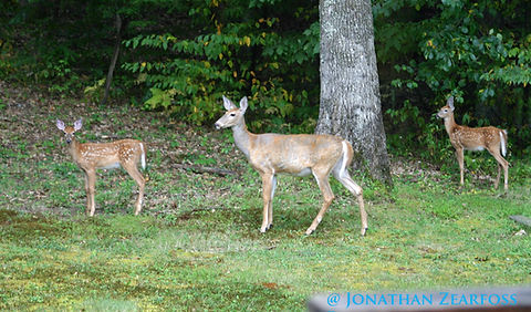
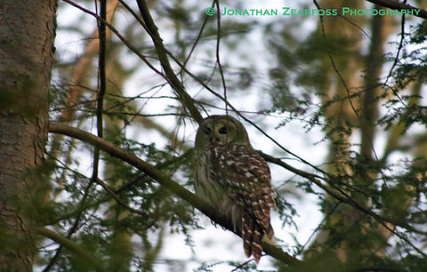
So, follow the events sequentially, jump around, read, view, look at the photos, learn, and, most of all, enjoy! Click on any of the photos on this page and you will be taken to a gallery of related images. If you feel like starting with the photographic galleries, please do, but please take the time to read about edge, the ecological phenomena that promotes such diverse abundance, as well as what the future holds.

Figure 1. Current Google Earth image with topographic and survey map overlaid. [3]

Figure 2. The 2.08 study area/property is in bright green, the area within the red box will be referenced on subsequent pages. [4]


Notes
[1] Karen A. Harper et al., “Edge Influence on Forest Structure and Composition in Fragmented Landscapes,” Conservation Biology 19, no. 3 (June 2005): 771.
[2] Aldo Leopold, Game Management (1933; repr., Madison: University of Wisconsin Press, 1986), 131.
[3], [4] Topographic Map, courtesy Town of Hyde Park, 2001.
Dalbo, Michael A. Survey Map. Lot #1, Filed Map #3924: Hollow Ridge Estates. June 27, 1995.
Google Earth. LAT 41 degrees 50' 26" N, LON 073 degrees 54' 46" W. 2016. Accessed March 16.2016.
Technical assistance, Alex DiCicco, The Culinary Institute of America.

